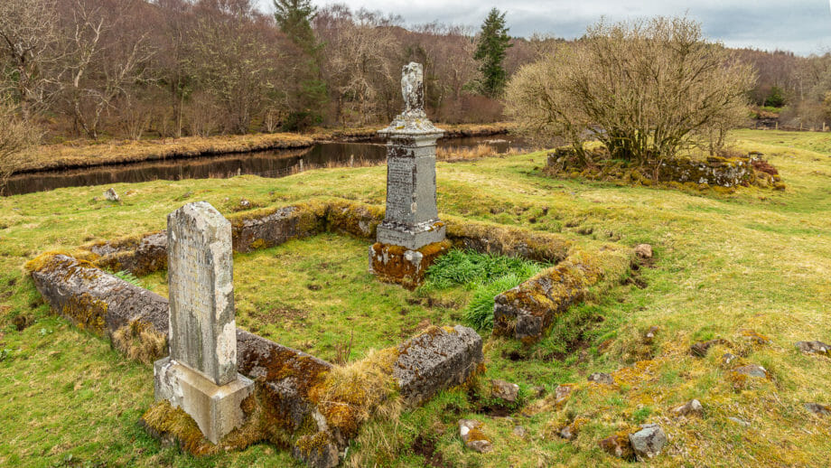
Hidden and overgrown on the Isle of Skye lies a religious centre of the Middle Ages – the Eilean Chaluim Cille.

A small chapel, an old graveyard, surrounded by water – for nearly 500 years this seemingly godforsaken place near Skeabost on Skye was the centre of Christians in the Hebrides. Hard to believe today.
Eilean Chaluim Cille is Gaelic for “Isle of Saint Columba.” Scotland’s great missionary, Saint Columba himself is said to have once preached from a stone at this site. No wonder a place of worship soon stood here as well.
This place, now abandoned, dilapidated and overgrown before us, was once the cathedral church of the Bishops of the Isles. Between 1079 and 1498 the Hebrides and the Isle of Man were a separate bishopric, which as “Sodor” – “South Isles” – was at first subject to the Archbishopric of Trondheim in Norway, but later became a part of the Kingdom of Scotland.
Around about 1134 the dazzling Wimund was bishop of the “sancta ecclesia de Schith” – the “holy church of Skye” here. Wimund apparently turned on the Bishop of Whithorn, to whom more and more parts of the islands’ bishopric were granted, by force of arms. Moreover, he is even said to have taken up arms against King David I of Scotland.
Not a very Christian demeanor, and harsh punishment promptly followed: Wimund was blinded, castrated, and then put in a monastery near York.
St Columba’s Isle retained its importance during the reign of the Lords of the Isles and into the Reformation in the 16th century. Later, the church served as the parish church of Skeabost.
For the Clan MacNeacail of Scorrybreac, incidentally, the churchyard has great significance. According to tradition, 28 chiefs are buried here, and as recently as 2003, the current clan leader scattered his father’s ashes here.
The Eilean Chaluim Cille is steeped in history, but relatively unknown and little visited. Yet the location is interesting in itself – the island is formed by two arms of the River Snizort and is overgrown with trees overgrown with lichen. The way there leads over bridges and boardwalks. And most of the time you can find some peace and quiet here.
Pictic stone: Clach Ard
There is a reason why Saint Columba chose this of all islands to proselytize. For Columba liked to “disenchant” Pictish holy sites. And such was the island in the river even in pre-Christian times.
That there were Picts here is proved by the stone which lies a little further north at the village of Tote. A visit to the richly decorated stone is worthwhile. It stands in a wooden enclosure just off the road. Clach Ard and Eilean Chaluim Cille can be explored in a short walk, which is about 2.5 kilometres long and takes about an hour if you allow yourself some time.
Since the path to the stone is uphill, it can be seen quite well that the Eilean Chaluim Cille actually forms an island.
Knowledge: Eilean Chaluim Cille and the Diocese of the Isles
The Hebrides, Orkney, Shetland and also the Isle of Man were part of the Archdiocese of Nidaros from the 11th century. Nidaros is now called Trondheim and is in Norway. From there, the archbishop there knew not only Norway and the Scottish islands, but also Iceland and Greenland under his ecclesiastical care.
The Hebrides thereby formed the diocese or bishopric of Sodor or “Suðreyar”. This means Southlands (to which “Sutherland” also owes its origin). Initially, the seat of this diocese was on St Patrick’s Isle near the Isle of Man. Later – when the Isle of Man fell to the English – the see was transferred to the Isle of Skye at Snizort on Eilean Chaluim Cille. The diocese was then called the Diocese of the Isles and covered the Outer and Inner Hebrides with few exceptions.
When the Norwegians eventually lost first the Hebrides and later Orkney and Shetland, the diocese was assigned to Scotland and St Andrews. The see also moved to Iona.
The coat of arms of the diocese shows St. Columba in a rowboat with a dove in one hand, looking up at a blazing star.
Approach and footpath
With sat nav: enter “IV51 9NR”, gets you to Skeabost.
Without sat nav: At Portree, follow the A87 north towards Uig. This forks after a while – right continues to Uig, left to Dunvegan. Turn left here. After some time a signpost points right towards Peinmore and Tote. Turn right here and immediately left again. In this way carefully look for a parking place where you are not in the way. Then continue on foot.
The footpath: Continue down the road at first. A gate appears at the end and a bridge behind it. In front of the gate there is already a signpost pointing to the right.
Go along the gravel path and then up to the bridge. That leads onto the boardwalk to the island.
If you still want to visit the Pictish stone afterwards, first go back to the road and walk a few meters on it towards the parking lot. Soon another small road goes uphill to the left. Follow this and – as soon as a gravel road branches off to the right – turn onto it.
Keep going until you reach another road at the top. Here you can see the fence around the stone bereist.
After visiting the stone, just go all the way back. Time for the whole visit about one hour.