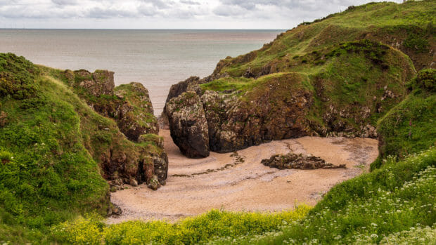
A small sandy beach behind a rocky outcrop, the vast sea beyond – that’s what a trip to Gutcher’s Isle and the Bogle Hole shows.

The coastline in the south of Scotland is less well known for its beauty than that in the northwest. But less well known doesn’t mean there aren’t great places here. One of them is Gutcher’s Isle near the village of Rockcliffe in Dumfries & Galloway. For there the rocky coast has formed some beauties.
This includes what is known as Bogle Hole, a rocky breach through which the sea flows, washing up a small sandy beach behind it. A short hike takes you there, passing several other small points of interest along the way.
Hiking is a big word for this short trip. Still, it’s along a coast into nature on trails that are muddy in places. That’s why the word might fit better than walk. Starting point is the small car park in Rockcliffe.
Since the municipality has built a parking lot in front of the village to relieve the residents, this is the starting point of the tour. After that, it’s on foot to the coast. Rockcliffe looks out over the Solway Firth, with England already on the south side. The sea has washed out a beautiful landscape here, consisting of brown rock and beige sand, fringed by green meadows.
The trail heads south along the coast – so coming from the road, it’s “left”. Already there are nice views of the big bay here.
If you keep your eyes open, you’ll spot Nelson’s Grave along the way. Joseph Nelson was a passenger on the ship “Ann” which sank off the coast here in 1791. His body washed ashore here and he was buried here. His widow erected the memorial stone. There was no trace of anyone else on the ship.
Overland, the trail can be shortened somewhat, though some elevation gain is required. Some gate doors remind the hikers that they are on private farm land. Back along the coast, some steep cliffs reveal themselves.
Now it’s just a bit and a hill, and the Bogle Hole of Gutcher’s Isle appears.
When the tide is out and you feel fit enough, you can climb down a path (sometimes using your hands). At the bottom, a beige sand and pebble beach and the rocky break await.
When the sea is low, it is also possible to walk through the stones. Views of the Solway Firth then open up – if you have some time, sit on one of the rocks and enjoy. Afterwards the path leads back to Rockcliffe. This reveals Castle Hill, which can still be visited on the way back.
The walker then soon rejoins the better-laid path on the coast below Rockcliffe.
Route: Rockcliffe – Gutcher’s Isle
The tour is about five kilometers long and you should wear sturdy shoes.
Directions
With sat nav: Entering the postcode “DG5 4QQ” into the sat nav will take you to Rockcliffe.
Without sat nav: At Dalbeattie, head east first, then take the A710 to the Solway Coast. Continue on it until a smaller road turns off to Rockcliffe and the Beach. Just before entering the village, drive into the large car park and park here. Please do not drive down into the village out of consideration for local residents.